Project Overview

Zandspruit, like much of the City, consists of low-density housing areas which lack a viable public transport system. This has led to residents commuting daily, often at considerable cost, with long distances to access work and economic opportunities. The City’s Transport Department therefore wants to develop a practical medium to long term solution to the transport challenges in Zandspruit and surrounding areas which will also help to create a more efficient and compact urban form.

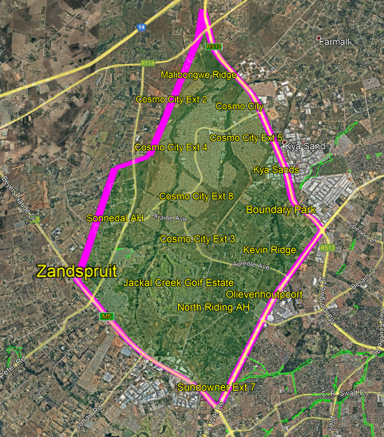
The boundary to the study area is formed by Malibongwe Drive to the north-east, Northumberland Avenue to the south-east, Beyers Naude Drive to the south-west and the municipal boundary between the City of Johannesburg and Mogale City to the north-west. The study area includes Zandspruit, Cosmo City, North Riding Agricultural Holdings (AH), Sonnedal AH and Malibongwe Ridge as shown in the map provided..

The Merchelle’s Collective, a team of professional consultants comprising transportation, urban design and planning, and stakeholder engagement specialists, have been appointed to carry out the project. The project team will first conduct a detailed review of the existing transport system in the area and its relationship with land use. They will then test ideas for transport options before developing a Transport Master Plan which will provide the transport planning for the study area and guide both public and private sector investment in infrastructure in the area over the next ten years.The 18-month project will be undertaken in four distinct phases.

Public participation will play an important role in developing the master plan because you will be asked to tell us about your challenges, issues and concerns as well as the good things about the transport system. You will also be asked to help with the design of the transport solutions for the area.

GET INVOLVED AND HAVE YOUR SAY!

To start the first round of stakeholder engagement we are having a 60-day public comment period which will begin on Monday 20 September and end on Monday 22 November 2021.By registering for the project we will also be able to invite you to meetings during the comment period so that we can present the project to you and discuss the transport situation in the area. To be invited to these meetings, which will take place in late October and early November, you must register by 8 October 2021.

We want to hear about your transport experiences and what you think about the transport services and facilities in the area. It doesn’t matter whether you drive your own car, drive a freight delivery vehicle, walk or cycle to school, the shops or work or whether you take the taxi or bus, your views are important to us.

In order to make the consultation as efficient as possible we will allocate people to 12 different sectors depending on where they live or the specific focus of the discussions for that meeting.

Geographically, the area has been divided into four different areas. The Zandspruit Informal Settlement forms one area. Cosmo City has been divided into two areas for the purposes of this study because it is very large. Cosmo City and Cosmo City Extensions 2, 4, 5 and 6 together with Malibongwe Ridge form one area while Cosmo City Extensions 7, 8, 9, 10 and 3 form another area. The last area contains the agricultural holdings and the mainly gated housing estates found in Jackal Creek Golf Estate, North Riding Agricultural Holdings, Kevin Ridge, Boundary Park, Olievenhoutpoort, Sonnedal Agricultural Holdings and Sundowner Extension 7. The transport situation in these areas is different and it makes it easier to focus on a specific area when discussing transport issues in a meeting. It is therefore important to include your address when registering to take part in the study so that we can allocate you to the correct area for these meetings.

The other eight sectors all deal with a specific mode of transport like minibus taxis, busses, scholar transport and metered taxis or a type of business, like informal traders, property developers and formal business associations. These meetings will be aimed at transport operators or business-people from those sectors.

The meetings will take place online using Microsoft Teams as well as streaming the meeting to the Cosmo City Multi-Purpose Community Centre which will be set up as a Covid-19 safe venue for those who do not have access to the internet.

So please register on this site on or before 8 October 2021 by completing the online registration form if you would like to participate in the meetings. If you would like to make comments on the project webpage you can do so until 22 November 2021.

Phase 3: Release of Draft Transport Master Plan and Implementation Plan and Public Engagements

The Zandspruit and Surrounding Areas Transport Master Plan and Implementation Plan project is now in its third phase where the Draft Transport Master Plan and Implementation Plan is being released for a 30-day comment period from 11 November to 12 December 2022. A round of public engagements have been scheduled during this 30-day comment period and interested and affected parties are invited to attend any of these engagements to provide input on the draft report by or before 12 December 2022.

Phase 2 Ideation Workshops

The study has now moved into the second phase which involves the development of concepts and solutions to address the problems identified in the status quo assessment, together with scenario planning and modelling to test these solutions. This phase of the study includes another round of stakeholder engagement in the form of ideation workshops with key stakeholder groups and the community and community members and key stakeholders within the study area are invited to attend these workshops.

Transport Planning in the City of Johannesburg and the Zandspruit area

The City of Johannesburg (City) prepares many different plans to guide development in the City. The Joburg 2040 Growth and Development Strategy (GDS) was approved in 2011 and sets out the long-term development path for the City. It also provides the foundation for the five-year Integrated Development Plan (IDP) which is the main medium-term development plan for the City. The GDS also provides strategic direction for the other medium-term plans for the spatial, infrastructure, housing and transport sectors.

One sector plan that forms part of the five-year IDP is the Spatial Development Framework (SDF). The SDF 2040 was prepared in 2016 as a spatial policy document that sets the spatial vision for the City. The SDF directs sustainable urban growth and development to address the inequality and inefficiency in the City. Cities are largely founded on connectivity and access. They are places where people and businesses concentrate to gain access to services and amenities. These include jobs, economic activity, schools, healthcare facilities, services, cultural and religious experiences, leisure, entertainment as well as interaction with other people. The SDF says that the City needs to transform from a spread out, car-oriented city to a compact, polycentric (many different urban nodes), mixed use and walkable City. Compact cities are more efficient and productive. They are also more sustainable and promote the use of public transport rather than the private car. The future polycentric Johannesburg will bring jobs to residential areas and housing opportunities to employment areas rather than transporting people between the two. It will create complete nodes with good public transport connections where people can live, work and play and it will bridge spatial and social barriers to build a spatially just City.

Since the early 2000s, the City’s strategy for managing urban growth can be described as one of compaction to promote higher density, mixed use development in well located parts of the City, rather than outward sprawl (spreading the footprint of the city). Compact development allows people to live close to where they work and go to school and promotes easy access to public transport and other services. For this planning to work, high intensity development must be concentrated in clearly defined ‘well located’ areas. These areas are described as nodes in the SDF. The SDF required a review of existing nodes in the City and as a result the Nodal Review Policy (NRP) was completed in 2020. In the NRP the Zandspruit and Cosmo City node is termed a Local Economic Development Zone which has poor facilities, high unemployment and few economic opportunities. The NRP prioritises interventions that will create economic opportunities in these nodes.

The Comprehensive Integrated Transport Plan (CITP) is another sector plan that forms part of the five-year IDP. The City prepared the Strategic Integrated Transport Plan Framework (SITPF) as the first part of the CITP in 2013. The SITPF provides an overview of transport in the City and outlines nine strategies to achieve the transport vision and goals of the City. The main priority is to move away from private car use towards improved mobility and accessibility for people through improvements to the public transport system. The key strategy is Transit-Oriented Development (TOD), which aims to create strong, high-frequency public transport corridors with high density residential development alongside the corridors and complex, mixed land use development in the precinct nodes on these corridors. The City will develop integrated transport hubs in the TOD precincts and improve the surrounding public environment where it is unsafe or unattractive, particularly for pedestrians and cyclists. This will attract mixed use development and inclusionary, high density housing to the precincts.

The City has a Framework for Non-Motorised Transport (NMT) which has identified 7 priority areas for the implementation of NMT infrastructure and one of these areas is the Zandspruit / Cosmo City Priority Route to Northgate. The new Cosmo City Gautrain Station is being planned close to Northgate and this NMT infrastructure will now increase in importance. NMT refers mainly to walking and cycling which are most appropriate for feeder routes to public transport stops and stations or as the main mode of transport for short-distance, learner and convenience related trips. NMT also includes waste reclaimers who use trolleys, parents with prams, the elderly and very young, commuters with suitcases, as well as universal access for disabled users. Universal access refers to the elimination or reduction of physical barriers through design principles that ensure transport infrastructure and services are accessible to as many people as possible and especially those with special physical and mental needs. Internationally, distances from 500m up to 1km and walking times of 30 minutes to jobs or school and 15 minutes for trips to the shops or services are considered reasonable while destinations should be within 10km for cycling. Many trips in the City cover longer distances than this so NMT routes also need to help people reach public transport stops and stations. The City aims to prioritise cyclist and pedestrian movements within streets and provide independent cycle and pedestrian only paths that are separated from vehicles on roads with high traffic volumes. Safe routes to school, links to public transport facilties, security features like lighting, good sight lines, signage and CCTV cameras are all important features of NMT infrastructure as well as cycle storage facilities and lockers at transport facilities like Gautrain stations and taxi ranks or destination points such as schools, sports grounds and community facilities.

The current street environment does not prioritise pedestrian or cycle movements. When streets are designed and constructed for all road users they become safer, more attractive and user friendly. The City has introduced the Streets Alive programme which has an infrastructure component called “Complete Streets” with a strong focus on sidewalks, dedicated or managed lanes for public transport, cycling and freight, traffic calming, urban functionality and management as well as attractive public spaces. Complete Streets are streets which are safe and convenient for everyone, regardless of age, ability or mode of movement. The City wants all its streets to be “complete” in the long term and it will focus on creating continuous cycling and pedestrian routes and networks.

Public transport facilities are also a key priority for the City and it is important to make these facilities safe, secure and attractive if they are to attract good quality, mixed use development to TOD precincts. Pedestrian and cycle access and proper passenger information and signage are also essential components. The City has developed a new model for medium-sized public transport facilities which includes trading stalls, holding facilities, loading bays for buses, minibus taxis and metered taxis, wash bays, offices, a commuter square, ablution facilities, a control room with CCTV cameras, waste bins, a tower clock, destination boards and an intercom system. Smaller on-street facilities, where the road reserve is wide enough, may include loading bays, some holding bays, some trading stalls and other infrastructure. The City will ensure that all public transport facilities are well managed so that they are clean, safe, secure and do not become run down.

Proper planning for freight transport is also a key priority for the City. Freight transport is a vital component of the supply chain and is essential for economic growth in the City. Some of the negative impacts caused by loading and off-loading freight, such as double parking, can be addressed by the provision of sufficient loading bays which are properly designed with a minimum length of 12m and through proper policing to ensure bays are not used illegally by motorists.

The City’s Transport Department is responsible for all transport planning in the City and it has developed a high-level public transport, NMT and freight network plan which sets out the best transport mode for different routes. It also identifies the public transport routes for City investment, the NMT routes and a 10-year plan for funding. The Zandspruit and Surrounding Areas Transport Master Plan is a new transport planning project of the City’s Transport Department.

Pin Feedback on the Study Area

Instructions for Map Icons

Bus Stop

Instruction: Use to identify location for a new bus stop or any other bus related issue

Cycle Lane

Instruction: Use to identify location for a cycle lane or any other cycling related issue

Loading Bay

Instruction: Use to identify location for a loading bay or any other freight or business related issue

Informal Traders

Instruction: Use to identify location for informal trade facilities or any other issue or problem related to informal trade

Minibus Taxi

Instruction: Use to identify location for a minibus taxi facility or any other issue or problem related to minibus taxis

Parking

Instruction: Use to identify location for new parking bays or facility or any other issue or problem related to parking

Pedestrians

Use to identify location for new pedestrian crossing, footpath or other pedestrian facility or any other issue or problem related to pedestrians such as pedestrian accident hotspot

Roads

Use to identify location for new link road or any other issue or problem related to roads like potholes, poor sight lines, accident hotspot, etc.

Traffic

Use to identify location of traffic congestion or any other issue or problem related to traffic

Other

Use to identify any other issues such as land use issues like the need for a park, or any other transport or traffic related issue or problem

How to add a comment

Step 1: Click on the relevant icon from the right-hand side panel and drag the icon to the location on the map where you want to make a comment

Step 2: Make your comment in the pop-up window and click 'Add Comment'.

Step 3: On a mobile device moving the map marker opens the comment form, minimise your mobile device sreen to move the marker into position.

How to use the map

Click + to zoom in

Click - to zoom out

When using a mobile device, click the hide button to minimise the comment form

To vote and reply to comments made by other people, click on the comment or map marker of the relevant comment.

  • Zandspruit and Surrounding Areas Transport Master Plan Study Area

    The boundary to the study area is formed by Malibongwe Drive, Northumberland Avenue, Beyers Naude Drive and the municipal boundary between the City of Johannesburg and Mogale City.